What if we told you that you don’t have to travel out of the urban environment to see millions of years of time, beyond even the existence of the city itself? Walking through the streets of Munich with a geological lens offers new insights into the city’s history, and this is what we want to showcase.
Our walking tour through Munich will take you to five sites of interest that represent the variety of uses and occurrences of geological formations in the city. You might already have some sites in your head, but we think we’ve found some that won't have crossed your mind!
1. Interactive Map
Interactive map showing the route and stops of the walking tour. Click on the headings of each stop to jump to the relevant section of the website!
The walk covers around 4 kilometres and will take approximately 2.5 hours to complete.
2. A Detailed Look into Each Site
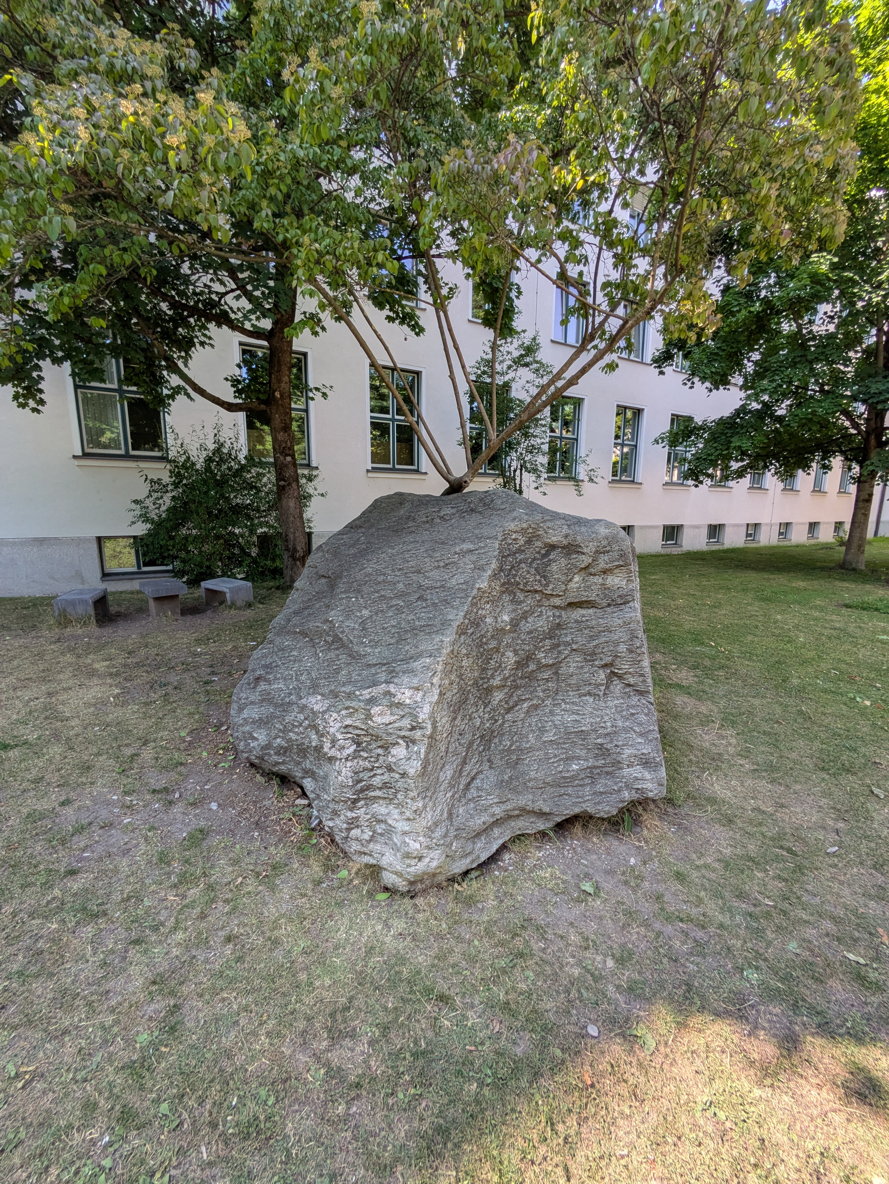
2.1. Glacial Erratic
Where better to start our tour than outside the building which hosts Munich’s Palaeontological Museum, Geological Museum, and the LMU’s Geology department? Before beginning our tour, we highly recommend that you take a wander inside and admire the impressive collection of ancient fossils, rocks, skeletons, and more! Admission is free and opening times can be found here.
Now, after this brief intermission, it is time to begin the route. Hopefully you got the chance to explore the geological exhibitions and get some background information, but if not then don’t worry! As two environmental humanities students with freshly acquired geological knowledge, we are here to (both literally and metaphorically) walk you through Munich’s geology in a way that is digestible for a broader audience. Our first stop, the glacial erratic, serves as a valuable starting point for narrating the processes that have shaped the city’s familiar landscape. Go up to it now and have a look and feel around, seeing what distinctive markings you can see.
On the scale of rocks, this is certainly a big one. You may be wondering how such a big rock could end up here in central Munich. The honest answer: by human transport 😆 However, it arrived at its previous home – Wasserburg am Inn – by other means. The term “glacial erratic” alone gives a strong indication of the mechanisms which define this boulder: “glacial” refers to large, slow-moving ice masses formed during glacial (cold) periods within an ice age, while “erratic” is denoted from the Latin word errare, meaning “to wander.” It follows, then, that glacial erratics are rocks which were eroded from a larger mass and carried by expanding glaciers over many kilometres (and many millennia!) before being deposited where the glacier melted. A glacial erratic is thus characterised by a geological make-up which differs from its immediate surroundings and can be traced back to a particular origin to understand glacial flows. In tracing the mineral contents, geologists came to understand the vast migrations undergone by these boulders. It was from such investigations into glacial erratics that 19th century geologists arrived at the theory of Ice Ages, a theory that has shaped geological thought ever since. More than a fascinating occurrence, then, glacial erratics are effective storytellers of deep time and souvenirs from an Earth abundant with ice. It is their absurdity within an otherwise consistent landscape which makes them so cool, and such incredible thinking tools when trying to grasp histories beyond the human!
Now you know more about glacial erratics in general, it is time to bring our focus back to the boulder standing in front of you. If it is not from Munich, why is it important for our city-specific geology tour? Well, this glacial erratic provides a perfect entry point into the Quaternary glaciation processes which have been the main drivers of shaping Munich’s geological landscape, albeit indirectly (since no glaciers reached Munich). The Quaternary period spans the last 2.6 million years and is characterised by intermittent glacial-interglacial cycles. It is worth noting that we say “intermittent” here considering the deep time of Earth’s history – on human timescales, tens of thousands of years certainly does not feel intermittent, but we must talk and think like geologists!
Figure 1 below shows a cross section of the geological strata (layers) beneath Munich and its surrounding area, alongside the moraines (Moränen – ridges of rock and debris) which mark the peripheries of historic glaciers. We know this diagram looks confusing to untrained eyes, so we want to draw your attention to a couple of focus points. Firstly, the end moraines (Endmoränen) circling Rosenheim towards the top of the diagram mark the approximate area where the glacial erratic in front of you was found! And secondly, the city of Munich is shown to lie on the Munich Gravel Plain (Schotterebene), a vast outwash plain formed when Alpine glaciers melted and released water downstream, carrying thick layers of gravel, sand, and silt into the Munich area (Neumann 2006). These flows of so-called “glaciofluvial sediments” arrived in particular abundance during the Würm glaciation (~90,000 to 10,000 years ago), as will be expanded upon in the context of the gravel-rich Isar Terraces. As an additional note of interest, it is fascinating to see in Figure 1 how moraines surround both the Ammersee and Starnberger See, evidencing (1) the significance of glacial processes in shaping the environment, and (2) just how close the glacial fronts were to Munich!
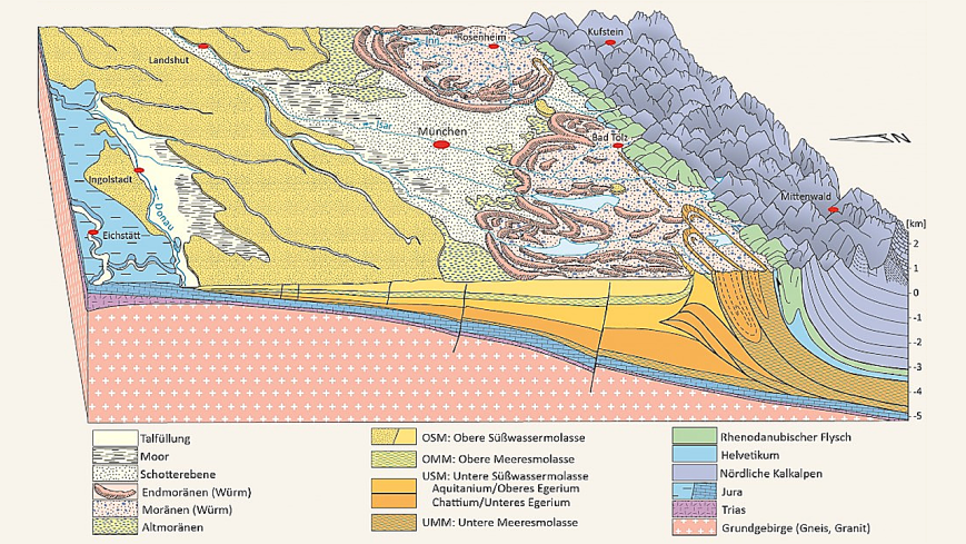
Diagram showing a cross section of the geological strata below Munich and its surrounding area (Meschede 2018).
Of course, there is so much more information in this diagram that we could dive into, with multiple strata dating back millions of years. This is too much for us to explain within our tour, but is certainly worth looking into further if you’re interested! For now, though, our main hope is that you can begin to grasp the deep time required to create the ground beneath urban spaces, and the significance of glaciation processes in shaping the geological fabric of Munich specifically. And to think we started this discussion with one supposedly “big” rock that now seems tiny compared to the colossal-scale processes that forced the movement of both the glacial erratic in front of you and the sediment beneath your feet! With this, I hope you are beginning to feel excited about what we will tell you next, because we certainly are.
Bringing glacial erratics to the humanities?
➡ Beyond geology, glacial erratics can also be employed as metaphors for human migration across the globe, as explored by Stephanie Krzywonos in the book Living with water: Everyday encounters and liquid connections (Krzywonos 2023).
➡ In his poem “Erratic,” David Hellerstein narrates a tale of how glacial erratics, which have witnessed hundreds of thousands of years of history, are increasingly threatened by humans, and what this means to him (Hellerstein 2007).
2.2. Hochschule für Musik und Theater
Geology surrounds us every day even if we don’t always notice it. The buildings around you, for example, hold stories that connect the Earth’s deep history with human society. Construction stones, often overlooked, reveal much about geological origins, composition, and durability – but they also reflect social, economic, and political forces. The building stones chosen depend upon a variety of logistical, economic, and aesthetic factors as will be shown in the case of the Hochschule (Schroeder 2009, 23-24).

Arcisstraße 12: The Hochschule für Musik und Theater in the former "Führerbau."
The building you stand in front of has been home to the Hochschule für Musik und Theater, or University of Music and Performing Arts, since 1975. It was originally constructed, however, as the “Führerbau” during the Nazi era, built primarily for show. Hitler’s office was in here, and it was in this building that the Munich Agreement (the consensus between Germany, Great Britain, France, and Italy that ceded the Sudetenland, a region of the Czech Republic, to Germany) was signed on September 29, 1938 (Rabe 2025).
The architect Paul Ludwig Troost was commissioned in 1933 to build the Führerbau as part of the Nazi Party’s plan to reshape the Königsplatz and its surroundings. To make way, several houses on Arcisstraße were expropriated and demolished. Completed in 1937, this building was designed to reflect the Nazi’s authoritarian ideology. Their ideas are inscribed both into the building's architectural and geological assets in terms of materials (formation, availability, extraction, and construction) and meaning (Rabe 2025). From a contemporary standpoint, this got us thinking: What associations might the stones awaken through their aesthetics and origins? How do these materials contribute to the building’s imposing presence? Why were all the stones quarried within Germany, mostly in Bavaria? Could the ‘naturalness’ of these stones have been chosen to reflect the Nazi ideal of purity? It's important to ask these questions to remain critical about the built environment.

Entrance on the right with natural construction stones chosen by architect Paul Ludwig Troost.
Take a look at the outside of the building. What you see is limestone, a kind of sedimentary rock. Sedimentary rocks originate at or near the Earth’s surface when sediments are weathered, moved, deposited, and then hardened through compaction and cementation. They form layered strata and often preserve fossils, offering snapshots into Earth’s history. Limestone forms mainly from the accumulation of marine organisms' shells and skeletons, which are rich in calcium carbonate (CaCO₃). Over time, these materials compact and cement together under pressure, forming solid rock (Weber and Musso 2015, 9).
On the plinths and stairs around green areas you can see a specific kind of limestone: Kelheimer Auer limestone (Kelheimer Auerkalkstein), which dates back to the Jurassic period, about 140 to 200 million years ago. The building’s facades, on the other hand, feature Franconian shell limestone (Fränkischer Muschelkalk), which is even older, from the Triassic period 200 to 250 million years ago. Both types of limestone are quarried in Bavaria, with the shell limestone also found around Würzburg (Schroeder 2009, 246). After excavation, natural stones are shaped into patterns like ridges or polished into smooth surfaces:

Kelheimer Auerkalkstein, processed with ridges.

Fränkischer Muschelkalk, polished.
If you stand in front of the building and look down at your feet you see paving slabs made from Kösseine granite, quarried in northeastern Bavaria. Granite is an intrusive magmatic rock that forms deep underground when molten magma cools slowly, allowing large crystals to develop. This blue-grey granite here was formed in the Carboniferous, about 300 million years ago, and is mostly found in Schurbach, Kösseine, and the Fichtelgebirge mountains. You easily recognize it by its large blue crystals and dark mineral flecks. The same type of stone, though in larger square-meter slabs, was also used to pave the Königsplatz from the 1930s through the 1980s (Schroeder 2009, 246). Therefore, the granite here serves as a stark reminder of how the Nazis reshaped public spaces to assert and display their power.
Kösseine Granite.

Parade of the Nazi Party (NSDAP) on Königsplatz with granite paving stones, November 9, 1936. The "Führerbau" is visible on the upper left-hand corner. Via the website of the NS-Dokumentationszentrum München n.d. © Bayerische Staatsbibliothek München.
Now, go inside the building to find the floor and stairs made out of Saalburg Altrot, or Saalburg marmor, a type of limestone that can be quarried in Thüringen. This limestone is the oldest stone used in the construction of the Führerbau, dating back to the Devonian, approximately 350 to 400 million years ago. It was used in many buildings Hitler commissioned (Schroeder 2009, 246).
Saalburg Altrot inside the building

Saalburg Altrot
As you move to the next site, maybe you can take some time to think about the following questions: How do the very stones used in this building preserve and evoke memories of a dark chapter Munich would rather forget? How does geology, through these stones, connect us to memory – both preserving history and challenging us to remember the city’s history as a Nazi capital and the events that unfolded here in the Führerbau? Only by remembering the past can we act responsibly in the present.
2.3. Frauenkirche
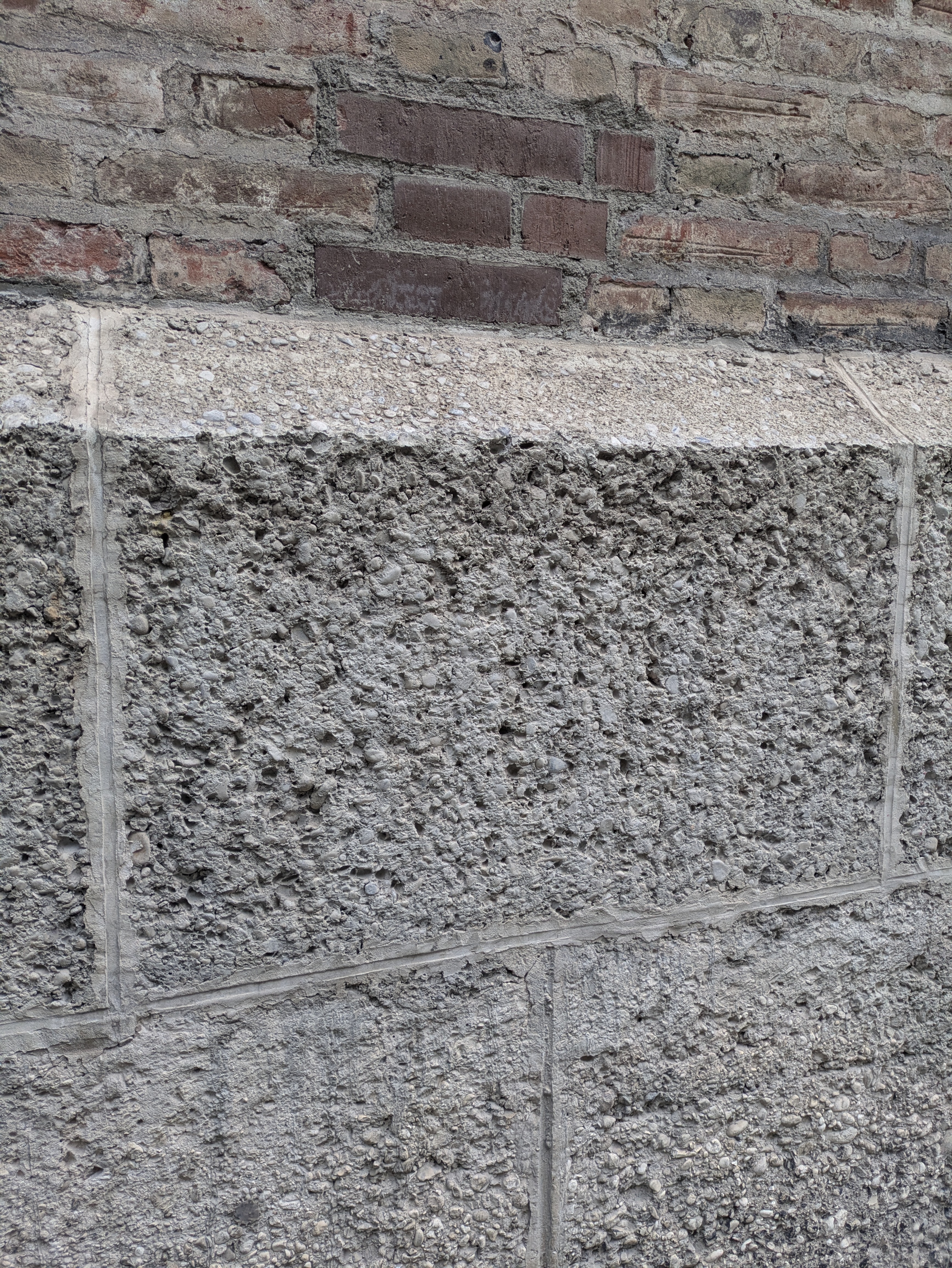
No walking tour of Munich would be complete without a stop at the Frauenkirche, the city’s landmark with its iconic towers and red bricks. The construction stones of the church hint at the importance of clay for Munich's urban expansion. The story lies beneath your feet – and begins tens of thousands of years ago (Schneider 2017).
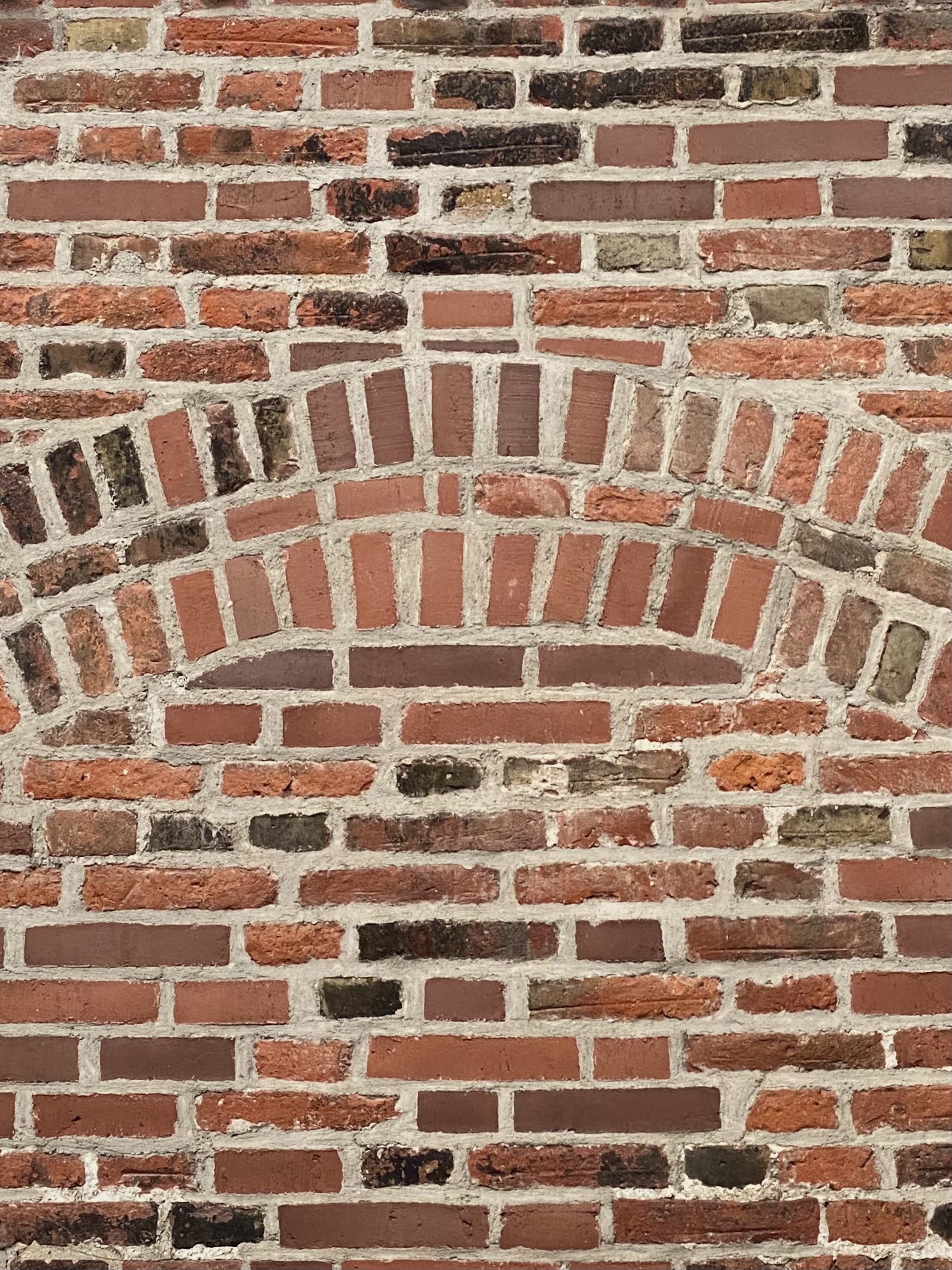
Red Bricks of the Frauenkirche made of clay quarried in Haidhausen
As you’ve read before, Munich sits on the so-called Munich gravel plain: a flat, stony landscape left behind by massive glaciers that once slid down from the Alps during two last Glacial Periods in the Pleistocene (Riss and Würm). The glaciers carried with them a mix of rocks, gravel, and fine sediment, spreading it north across the region. With the help of wind and water they also brought loam (Lehm) to Munich, a dense, rich, clay-like soil perfect for making bricks. This material was deposited as a ribbon of clay, called the Lehmzunge or "tongue of loam" that is up to four meters thick and runs in the East of Munich from Ramersdorf to Ismaning (Schneider 2017).
Let's jump to the year 1327, when a devastating fire swept through the city. In response, Emperor Ludwig von Bayern introduced a fire-safety measure: building houses with bricks. Thus, the fear of fire turned Munich into a city of bricks. By the late 1400s, more than 60 brickworks were in operation, particularly in the eastern districts like Oberföhring, Daglfing, and Haidhausen - the latter supplied the bricks for the Frauenkirche (Schneider 2017).
This new construction material created economic growth and a new class of wealthy industrialists: the so-called Ziegel- or Lehmbarone. After the manorial system ended in 1849, many farmers who owned loam-rich land sold it to these brick tycoons. Combined with the rise of industrialisation and the arrival of the railroads, brick production took off. From the early 1800s until about 1900, the clay-rich land was gradually mined out (Winkler-Schlang 2016). Brickworks then moved further north into areas like Bogenhausen and eventually Ismaning. The connection between Munich and its clay is still captured in a local saying: “Ohne Lehm daat’s München net geb’n” (Lehrberger and Thuro, 34) – without clay, there would be no Munich.
But brick wasn’t just an economic engine – it came with environmental and human costs. The massive demand for fuel led to deforestation, while the brick factories polluted the air and water. Working conditions were harsh: hot, seasonal, noisy, and often dangerous. Many of the workers came from Friuli in northern Italy, living in basic hostels near the factories. Some of those hostels still stand today. These early Gastarbeiter didn’t just help build Munich – they brought with them songs, food, language, and culture that continue to shape the city’s identity (Winkler-Schlang 2016). Today, the only surviving brickwork within Munich’s city limits is the Ziegelei Haid in Oberföhring, preserved as an industrial monument and a tribute to this chapter of the city's past (Schneider 2017).
As you walk further through Munich look around: the clay brick buildings are more than just architecture. They're silent witnesses to stories of the past shaped by glaciers, clay, migration, and labor.
➡ Additional Fact: If you take a look at the base of the Frauenkirche, you can detect another construction material that was brought by the glaciers. This is nagelfluh, a chalky conglomerate, made up of compacted gravel. It was often quarried from the slopes along the Isar River. Thanks to its porous yet stable nature, Nagelfluh is particularly well-suited for use in foundations, as it allows water to drain quickly without losing strength in case of flooding (Bitsch/Dorner 2017).
The foundation: Naglfluh - a chalky conglomerate made of gravel.
➡ If you want to explore natural stones further, consider visiting the Geological Institute another day to see the extensive collection curated by Munich’s legendary geologist Prof. Dr. Wolf-Dieter Grimm.
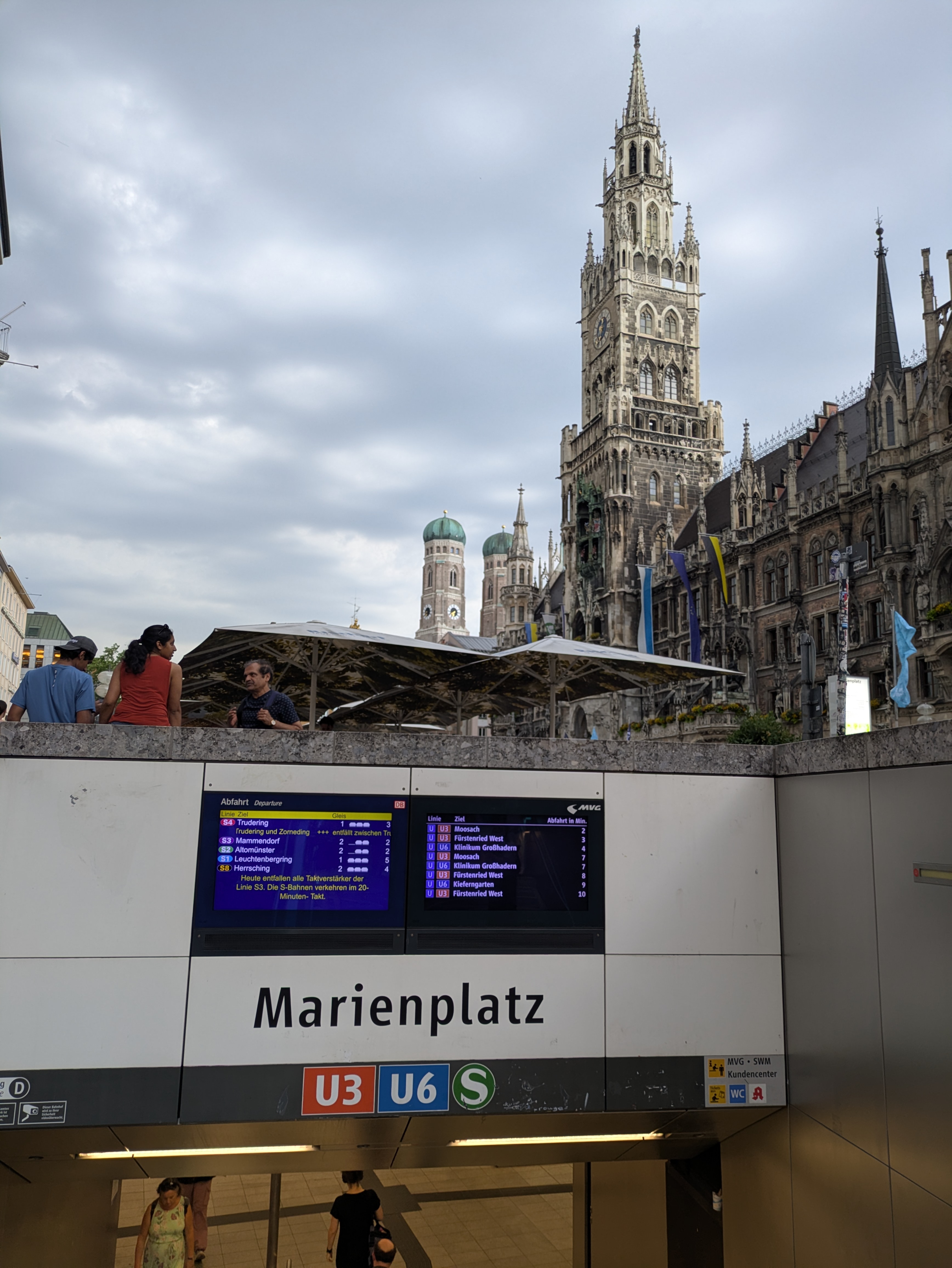
2.4. Marienplatz U-Bahn
Our next stop takes you to Munich’s most renowned square: Marienplatz. However, rather than focusing on the impressive buildings around Marienplatz (which we are sure you've done before), this time we are going underground. The U-Bahn is a facility that many of us use regularly, so much so that we often don’t even consider the complex expertise and technologies that had to go into building this vital infrastructure. We want to bring these processes to light to demystify this everyday infrastructure. This is especially significant in a geological context, as underground civil engineering projects such as U-Bahn construction not only require extensive localised geological knowledge, but have also been central in expanding it (Neumann 2006).
Marienplatz U-Bahn is a good locus for this underground exploration for three reasons: age, size, and cultural importance of surroundings. The U-Bahn station at Marienplatz was constructed to service Munich’s first ever U-Bahn line, the U6, which opened in 1971, shortly followed by the U3 in 1972 which was built to connect the Olympiapark with Munich city centre for the Olympic Games, enhancing mobility across the city. As the city grew and passenger traffic increased at the turn of the millenium, especially following the construction of the Allianz Arena (football stadium) in northern Munich and its associated U-Bahn station (Fröttmaning), the original design of the station became inefficient (Fillibeck et al. 2005). To manage increased human traffic, two new pedestrian tunnels were added parallel to existing platforms just 10 metres below the iconic New Town Hall (Neues Rathaus), as shown in Figure 12. With such a large and historical building aboveground, and later an active U-Bahn service, ensuring the ground’s stability became an even more arduous task as engineers were forced to work around the existing built environment without endangering the public. As we now know, the construction ended in success, with the planned pedestrian tunnels in use today (Figure 13).
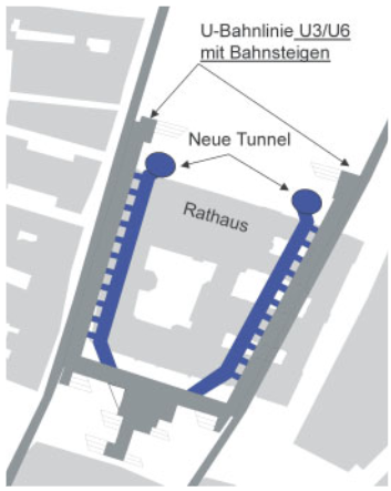
Diagram depicting where the new tunnels were planned for construction at the Marienplatz U-Bahn station (Fillibeck et al. 2005, 416).
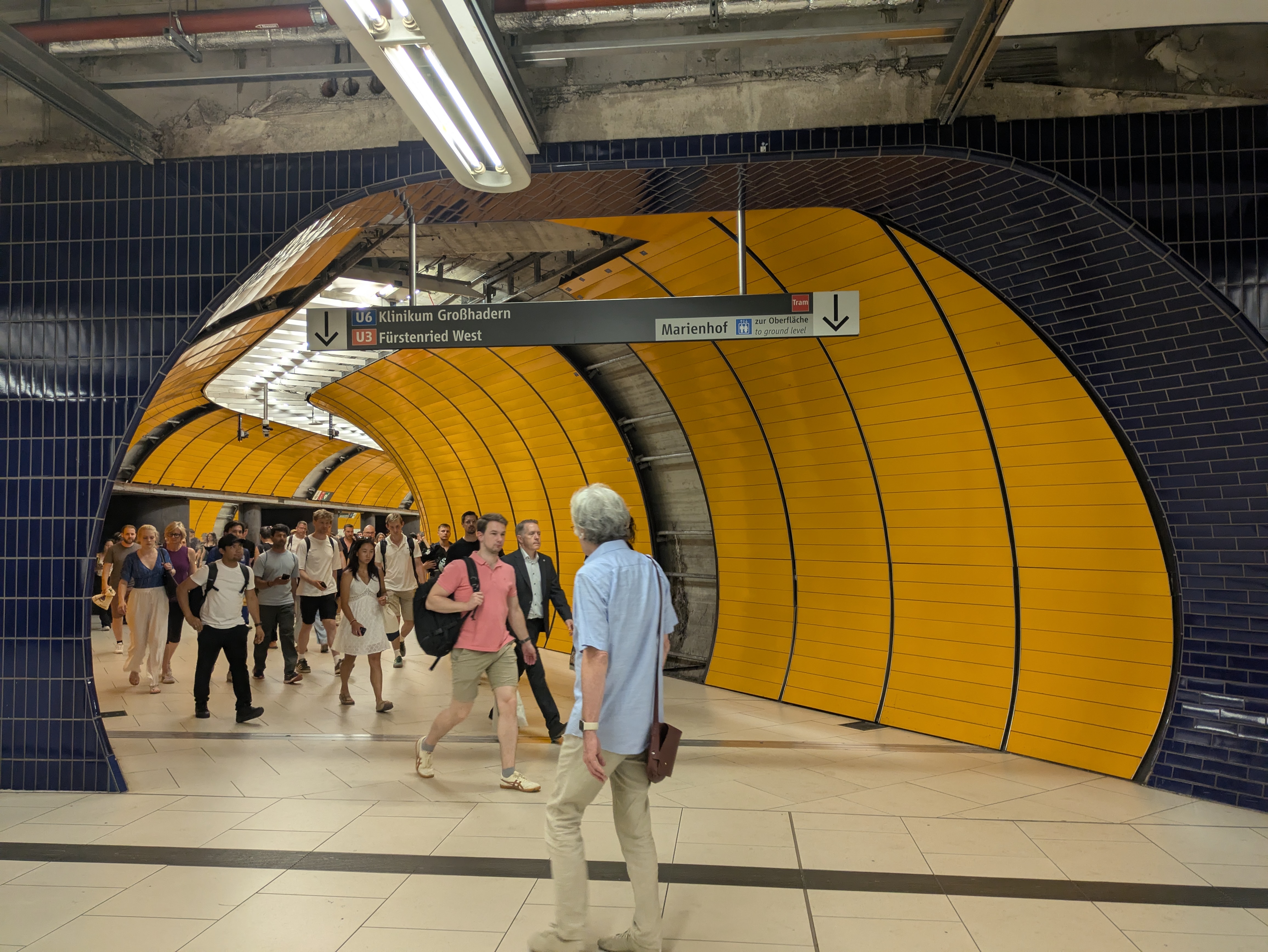
Picture showing pedestrian tunnels.
To ensure safe construction, geological knowledge becomes indispensable. Geologists can provide engineers with detailed ground models that show various criteria including strata thickness and materiality, groundwater extent, and potential existing cavities (Figure 14). This information is combined with assessments of above-ground traffic volume and buildings. In the case of Munich, the subsurface is characterised by two strata: the upper layer is made up of the Pleistocene gravel deposits that make up the Munich Gravel Plain, and the lower layer consists of Tertiary sediments (clay, silt, marls, sand) locally called “Flinz,” visible in Figure 15 (Scholz and Scharrer 2006). In providing this profile, geologists become key informants of where extra precautions are needed to ensure no groundwater leakage or gravel loosening. We know this information is quite technical, so we can sum it up in just a few words: without geologists, the U-Bahn would not be safe, and we would know a lot less about Munich’s underground world!
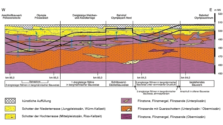
Diagram showing geological strata underneath the surface as modelled during construction of the Olympiapark U-Bahn station (Scholz and Scharrer 2006, 2).
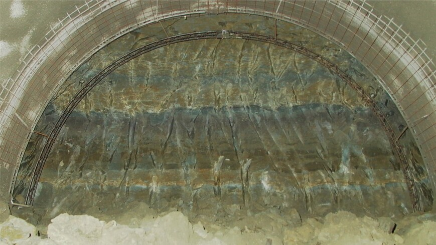
Photo of the Tertiary sediments, locally called Flinz, as revealed during U-Bahn tunnel construction (Baureferat München, from U-Bahn-Bau München 2025).
As you take a walk around the U-Bahn, take notice of the huge infrastructures required to hold the tunnel in place, think about which geological formations are surrounding you, and (if it’s not too scary for you!) about the structures that remain supported on the surface despite the tunnels throughout the city. The fact that we don’t have to think about these things while using the U-Bahn is a credit to the geologists who made it a secure space to be, and a highly efficient space to move within.
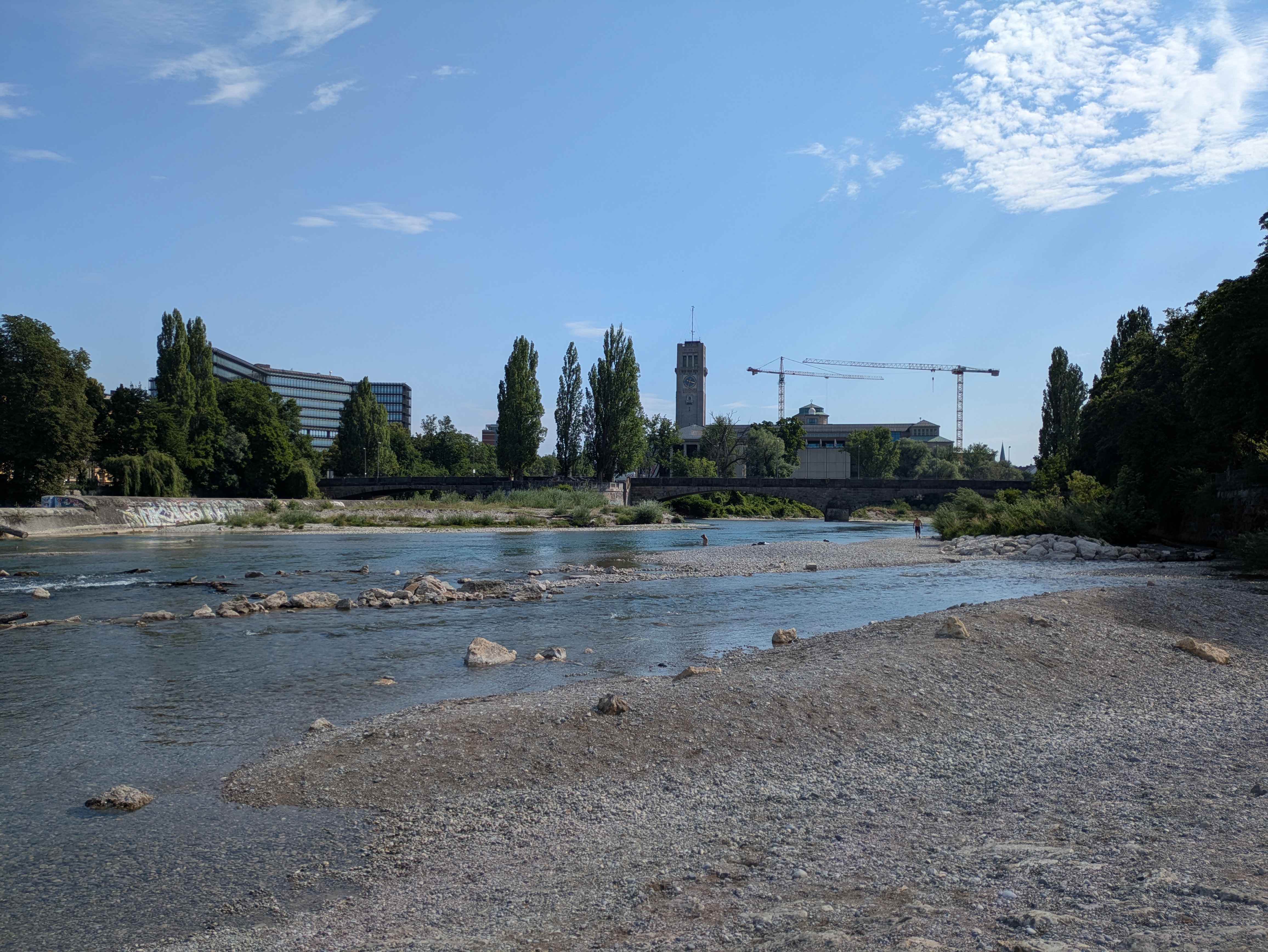
2.5. Isar Terraces
Cycling or walking through Munich, you might have noticed the gentle slopes across the city, and that they become a little steeper and higher on the eastern side of the Isar. Looking at Munich’s geology, you can clearly see the city’s distinctive terrace-like structure which is reflected in Figure 16. Again, we're pulled back in time to the Riss (about 300,000 to 130,000 years ago) and Würm (about 90,000 to 10,000 years ago) glaciation periods which shaped Munich’s landscape with erosion and deposition.
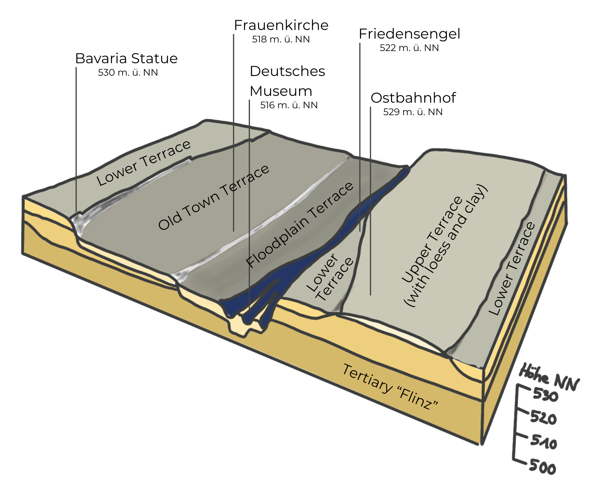
A model of the terraces and the underlying Tertiary sediments in the city area of Munich (Drawn by Klara Meyer after Lehrberger and Thuro).
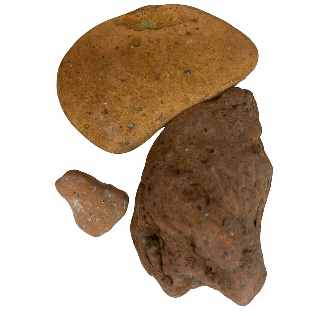
You’re currently standing on what’s known as the floodplain terrace – a flat, layered landscape shaped by repeated flooding events over time. Over human history, the Isar's channel has been reworked many times. The most recent effort was the Isarplan (2001–2011), a major project aimed at balancing flood protection with ecological and recreational goals (Wasserwirtschaftsamt München). The initiative reshaped sections of the Isar to make the riverbanks safer and more accessible for people, while also revitalizing habitats for plants and animals that depend on this unique ecological niche of the Isar gravel (Bitsch/Dorner 2017). Now let's take a closer look at that gravel shown in Figure 17.
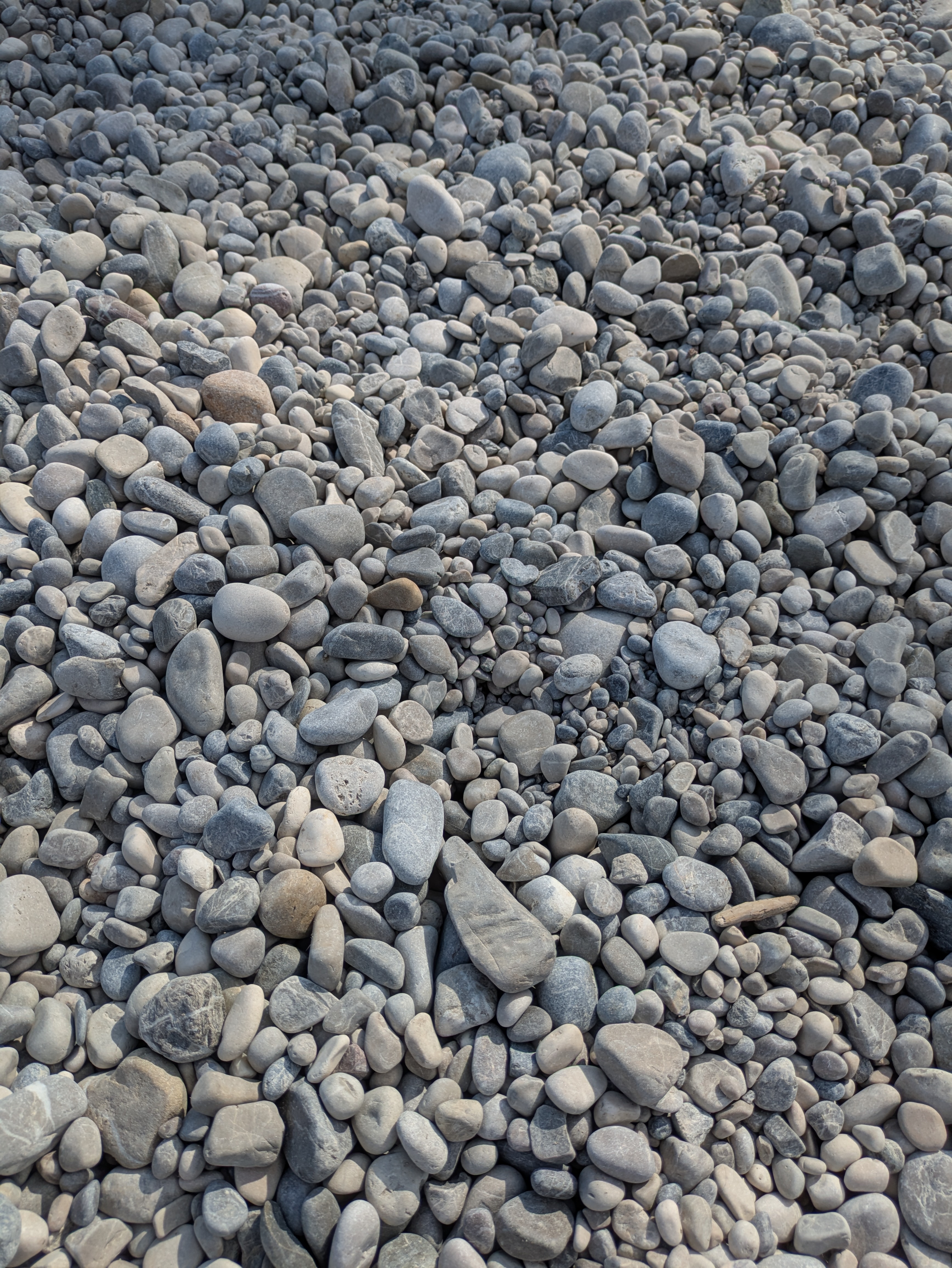
Isar gravel.
Rivers carry sediments across vast distances which have been shaped over inconceivably long timescales. The Isar is no exception. Every stone tells a story – of oceans long vanished, of tectonic forces at work, of glacial processes, and of rivers carrying their load across millennia. Each individual rock you see here connects you to the Alps and offers a glimpse into the Earth's deep past.
The Isar originates in the Karwendel Mountains in Austria, at about 1,160 meters above sea level. From there it flows roughly 280 km before joining the Danube near Deggendorf. The river’s gravel and sediments come from its wide catchment area, primarily the Northern Limestone Alps, but also the Central Alps and the northern Alpine foothills (Bayer).

A simplified model of the rivers Lech, Isar and Inn flowing into the Danube and of the different parts of the Alps where they originate (Drawn by Klara Meyer, after Bitsch/Dorner 2017).
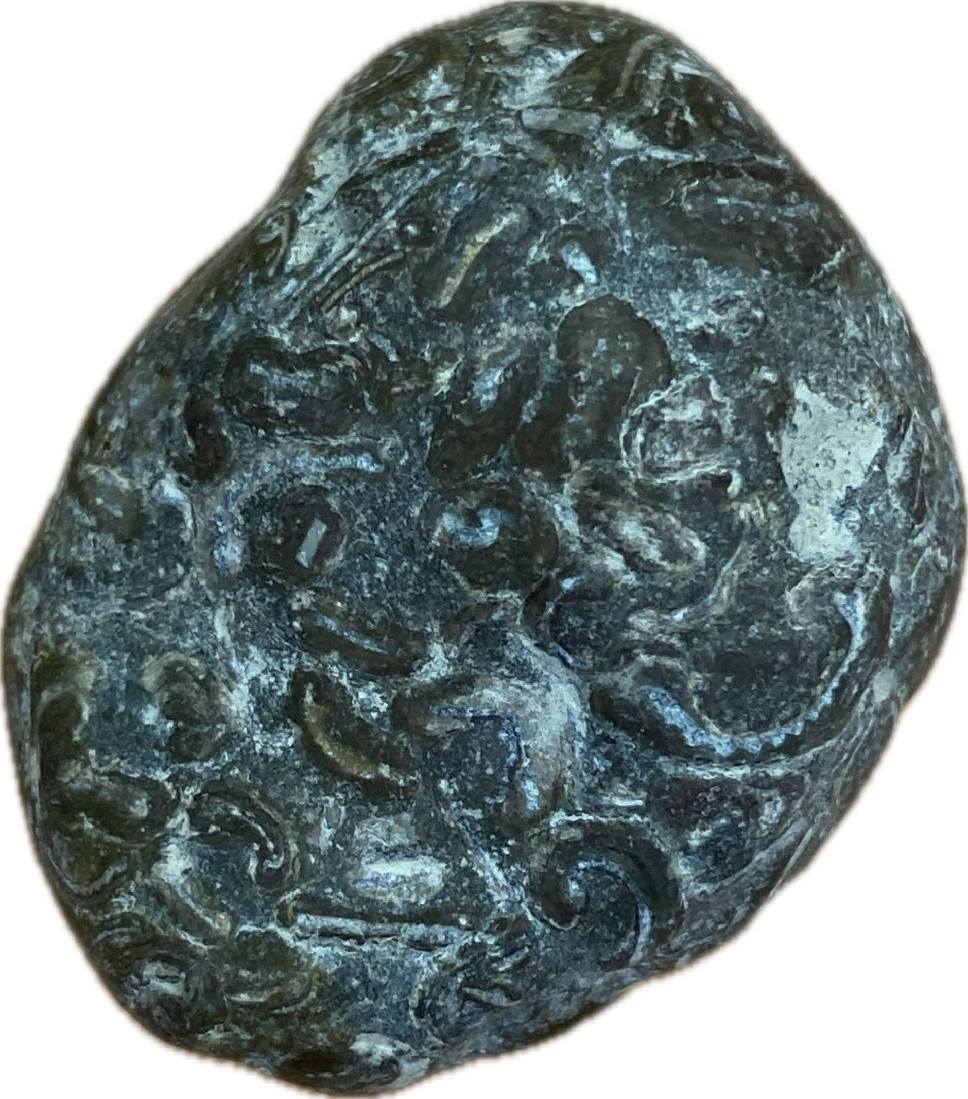
The majority of the rocks carried by the Isar are sedimentary rocks formed in the Tethys Ocean in the Triassic over 200 million years ago. These include shallow-water limestones and dolomites, like the Hauptdolomit and Wetterstein limestone – formations typical of the Karwendel range. They appear in different shades of gray, ranging from nearly white to deep charcoal (Bayer).
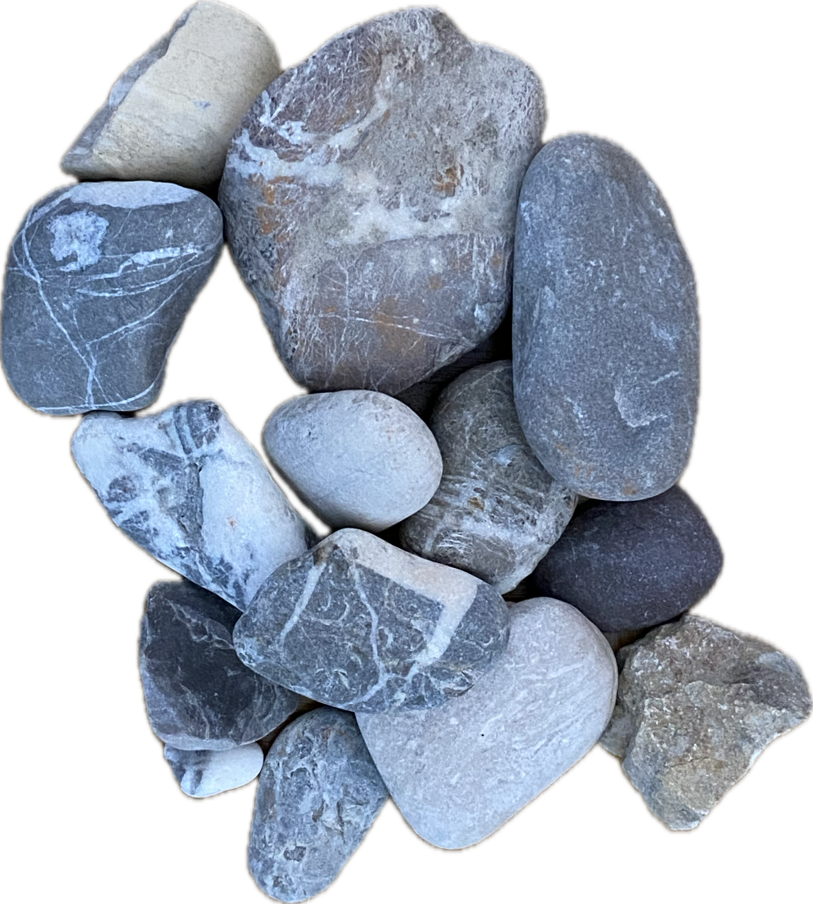
Shallow-water limestones and dolomites.
Why these old stones appear in the Isar has to do with formation of the Alps, known as the Alpine orogeny. This process unfolded over multiple phases lasting from 65 Ma to 9 Ma. As the African and European tectonic plates collided, the Tethys oceanic crust was subducted and sediments were uplifted into towering mountains, sometimes reshaped into magmatic stone (Encyclopedia Britannica 2011). Keep your eyes open: you can find fossils in the gravel if you’re very lucky!
A limestone with small fossils.
But how did these stones get here you ask? Much of the Isar’s gravel is glaciofluvial, meaning it was carried first by glaciers and later by meltwater streams (Bayer). As these stones are carried downstream, they are gradually ground down in size and rounded depending on their hardness and coarseness. Touch them and get a feel for their long travels 😉
However, the Isar today is more a transporter of existing material than a receiver of fresh rock debris. Since the construction of river engineering projects such as the Sylvenstein reservoir and other modifications in the last century, very little new weathered Alpine material reaches the riverbed (Bayer). Other anthropogenic modification of landscapes can be traced in the sediment load: brick stones hint at the urban environments the Isar flows through.
Fragments of bricks rounded by the waters of the Isar.
➡ Fun Fact: There are many Munich breweries on the banks of the Isar. But why? They settled near the river to take advantage of the cool temperatures in the gravel and sand slopes for storing and cooling beer in deep cellars, a method later enhanced by natural ice and, eventually, artificial refrigeration (Bauer and Meinelt 2017).
3. Conclusion
We have now reached the end of the route! Thank you for joining us on this journey through Munich's deep time. We hope that you leave this tour feeling inspired to see geology not just in distant, rocky landscapes. but also in urban areas. Perhaps viewing geology through a social lense has sparked a curiosity for the discipline that you didn't know you had - at least that's how it's been for us!
As the tour ends here, you can now reward yourself for taking this time and learning about Munich’s geology by strolling around this area – and maybe go for a little dip in the river 😀

Bibliography
- Bauer and Meinelt 2017 = Bauer, Lisa / Meinelt, Sonja (2017): Munich from Below., vol. Ecopolis München, 2, Virtual Exhibitions, Environment & Society Portal, Rachel Carson Center for Environment and Society [edited by L. Sasha Gora] (Link).
- Bayer = Bayer, Bernhard: Isar - Kiesel : Gesteine aus den Alpen, www.isar-kiesel.de (Link).
- Bitsch/Dorner 2017 = Bitsch, Stefan / Dorner, Alicia (2017): Stone-Rich, vol. Virtual Exhibtions, 2, Ecopolis München, Environment & Society Portal, Rachel Carson Center for Environment and Society [edited by L. Sasha Gora] (Link).
- Encyclopedia Britannica 2011 = Encyclopedia Britannica (2011): Alpine orogeny, The Editors of Encyclopaedia Britannica. (Link).
- Fillibeck et al. 2005 = Fillibeck, Jochen / Kellner, Christian / Rieken, Wolfgang / Scharrer, Stephan (2005): "Bahnsteigerweiterung der U6 unter dem neuen Rathaus in München – Spritzbetonvortrieb mit Vereisung." Bautechnik., vol. 82, 416-425.
- Frundmann/Scholz 1996 = Frundmann, Günter / Scholz, Herbert (1996): Kieselsteine im Alpenvorland. Suchen und selbst bestimmen: die Kieselsteine aus dem Einzugsbereich Iller, Lech, Isar, Inn, München, Christian Weise Verlag.
- Grundmann/Scholz 2006 = Grundmann, Günter / Scholz, Herbert (2006): Kieselsteine im Alpenvorland, München, Christian Weise.
- Hellerstein 2007 = Hellerstein, David (2007): Erratic, in: The North American Review, vol. 292, 2, JSTOR, 38-42.
- Kasberger 2008 = Kasberger, Erich (2008): LehmZiegelStadt: der Rohstoff Lehm in der Münchner Stadtgeschichte, Volk Verlag.
- Krzywonos 2023 = Krzywonos, Stephanie (2023): Glacial erratic, in: Living with water: Everyday encounters and liquid connections, Manchester University Press, 191-200 (Link).
- Lehrberger and Thuro = Lehrberger, Gerhard / Thuro, Kurosch: Geologie am Tagungsort München: Gesteine in und unter der TUM, in: Beiträge zur Jahrestagung München 25./26. Oktober 2013, 21.
- Meschede 2018 = Meschede, Martin (2018): Geologie Deutschlands: Ein prozessorientierter Ansatz, Springer-Verlag.
- Neumann 2006 = Neumann, PETER (2006): The geology of Munich (Germany) and its significance for ground modelling in urban areas..
- NS-Dokumentationszentrum München n.d. = NS-Dokumentationszentrum München (n.d.): Der Königsplatz in München (Link).
- Rabe 2025 = Rabe, Paul-Moritz (2025): Parteiviertel, vol. nsdoku.lexikon, NS-Dokumentationszentrum München, NS-Dokumentationszentrum München (Link).
- Schneider 2017 = Schneider, Julia (2017): The History of Munich and Its Loam, Seeing the Woods (Link).
- Scholz and Scharrer 2006 = Scholz, Markus / Scharrer, Stephan (4942006): Subway construction in the city of Munich - different ground conditions and different methods.
- Schroeder 2009 = Schroeder, Johannes H. (2009): Steine in deutschen Städten: 18 Entdeckungsrouten in Architektur und Stadtgeschichte, Berlin, Selbstverlag Geowissenschaftler in Berlin und Brandenburg e.V., ISBN: 987-3-928651-13-4.
- Siegesmund et al. 2010 = Siegesmund, Siegfried / Grimm, Wolf-Dieter / Durrast, H. / Ruedrich, Joerg (2010): Limestones in Germany used as building stones: An overview, in: Geological Society, London, Special Publications, vol. 331, 37-59 (Link).
- U-Bahn-Bau München 2025 = U-Bahn-Bau München (2025): Der Münchner Baugrund (Link).
- Wasserwirtschaftsamt München = Wasserwirtschaftsamt München: DER ISAR-PLAN (Link).
- Weber and Musso 2015 = Weber, Johann / Musso, Florian (2015): Natursteinführer München, Franz Schiermeier Verlag.
- Winkler-Schlang 2016 = Winkler-Schlang, Renate (2016): Vom Schuften auf der Lehmzunge, Süddeutsche Zeitung (Link).